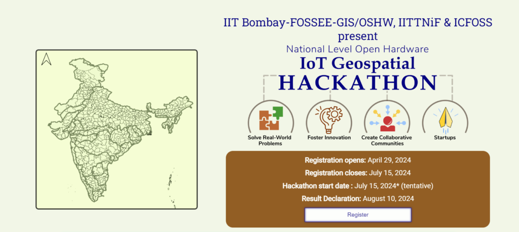
Applications are invited for the IoT GIS Hackathon 2024, organized by IIT Bombay FOSSEE-GIS/OSHW, IITTNiF & ICFOSS. The last date to register is July 15, 2024.
About IoT Geospatial Hackathon 2024
Welcome to the National Level Open Hardware-IoT Geospatial Hackathon, a stage where innovation knows no boundaries. This premier event brings together visionaries, tech enthusiasts, and problem solvers from across the nation to harness the power of open hardware, the Internet of Things (IoT), and geospatial technology. Get ready to explore uncharted possibilities, collaborate on real-world challenges, and significantly impact our world.
Significance
- In a world where technology shapes our daily lives, the significance of this hackathon cannot be overstated. Here, participants can redefine the boundaries of what’s possible. By merging open-source principles with cutting-edge technologies, we aim to:
- Solve Real-World Problems: Tackle critical issues such as environmental sustainability, disaster management, precision agriculture, and more. Your solutions can change lives and protect our planet.
- Foster Innovation: Innovation thrives when knowledge is shared openly. By promoting open-source hardware and IoT, we empower you to push the boundaries of creativity and discovery.
- Create Collaborative Communities: Through this hackathon, we build communities of like-minded individuals passionate about making a difference. Together, we can achieve more than any one of us can alone.
- Empower Future Leaders: Whether you’re a student, a professional, or an enthusiast, this hackathon is a launchpad for your ideas. It’s a chance to develop your skills, showcase your talents, and make your mark on the world.
Join them on this extraordinary journey, where innovation knows no bounds. Together, let’s turn ideas into actions and make a lasting impact on society and the environment. The Open Source Hardware IoT GIS Hackathon is your stage to shine; the world is waiting to witness your brilliance.
Purpose
This hackathon is more than just a competition; it’s a platform for innovators, creators, and visionaries to come together and pioneer solutions for a brighter future. They aim to harness the power of open-source hardware, the Internet of Things (IoT), and Geographic Information Systems (GIS) to address some of the world’s most pressing challenges.
The FOSSEE project, IIT Bombay, promotes the use of Free/libre Open-Source Software in academia and Industry. The project is funded by the National Mission on Education through ICT (NMEICT), the Ministry of Education, and the Government of India. The FOSSEE-GIS team manages the overall coordination of the “IIT Bombay FOSSEE GIS Internship in Geospatial Dashboard Design and Implementation.”
Partners and Organizers
Main Organizer: IIT Bombay FOSSEE GIS & OSHW project (NMEICT, Ministry of Education, Government of India) The IIT Bombay FOSSEE GIS & OSHW project teams are the main organizers of this National Level Geospatial IoT Hackathon 2024 (Edition 01). FOSSEE promotes the usage of Free/free open-source software in academia and industry and is funded by the National Mission on Education through ICT, the Ministry of Education, and the Government of India.
Technical Partner: The Rural Data Research and Analysis (Rudra) Lab, IIT Bombay, is India’s first HPC-powered data centre dedicated to Rural Development.
Organizing Partners: IITTNiF (NM-ICPS, DST, Government of India) & ICFOSS (Government of Kerala): The IIT Tirupati Navavishkar I-Hub Foundation is the Technology Innovation Hub of IIT Tirupati specializing in Positioning and Precision Technologies, funded through the National Mission on Interdisciplinary Cyber-Physical System (NM-ICPS), Department of Science and Technology, Government of India. ICFOSS: The International Centre for Free and Open Source Software (ICFOSS) is an autonomous organization set up by the Government of Kerala, India, and has the combined mandate of popularizing Free and Open Source Software for universal use, consolidating the early FOSS work done in Kerala; and networking with different nations, communities, and governments to collaboratively promote FOSS
Problem Statements
- Design and implement a system utilizing IoT sensors to track traffic flow, congestion levels, and parking availability in urban environments. Integrate this data with GIS to provide real-time maps.
- Utilize IoT sensors and GIS for urban environmental monitoring, pinpointing pollution (air, water, noise, urban heat islands) hotspots.
- Create an IoT precision agriculture solution using soil and crop data with GIS for optimized irrigation, planning, and resource allocation, boosting agricultural productivity sustainably.
- Create an integrated system utilizing IoT devices to monitor natural disasters, merging IoT data with GIS to evaluate damage, identify vulnerable zones, and streamline rescue and relief operations.
- Design and develop an IoT device using open hardware components such as Arduino or Raspberry Pi, equipped with sensors to monitor environmental parameters like temperature, humidity, air quality, and soil moisture. Integrate GPS module for geolocation data. Create a GIS application to visualize and analyze the collected data, allowing users to identify patterns and trends in environmental conditions over time and space.
- Develop an open hardware-based IoT system for early detection and warning of natural disasters such as floods, landslides, or forest fires. Utilize sensors to monitor relevant environmental parameters like water levels, soil moisture, temperature, and humidity. Incorporate GPS for precise location tracking of potential disaster zones. Implement GIS techniques to create hazard maps and establish risk zones, enabling timely evacuation and emergency response planning.
- Create an IoT solution using open hardware for monitoring wildlife habitats and tracking endangered species. Develop sensor nodes to collect data on wildlife movements, habitat conditions, and environmental factors. Integrate GPS modules for accurate geospatial tracking of animals. Utilize GIS tools to analyze the collected data, identify critical habitats, and plan conservation efforts effectively to protect endangered species and preserve biodiversity.
- Design an IoT-based system using open hardware components to optimize waste management processes in urban areas. Develop sensors to monitor waste levels in bins and containers across the city. Implement GPS for location-based monitoring of waste collection routes. Utilize GIS techniques to create dynamic waste collection schedules, optimize route planning, and minimize operational costs while ensuring efficient waste disposal and recycling practices.
How to Register?
Interested candidates can directly apply through this link.
Important Dates
- Registration opens: April 29, 2024
- Registration closes: July 15, 2024
- Hackathon start date: July 15, 2024* (tentative)
- Result Declaration: August 10, 2024
Registration Fee
Participation in the “National Level OpenHardware-IoT based Geopstial Hackathon” is completely ‘FREE OF COST/ NO FEE”.
Deadline
The last date for registration is July 15, 2024.
FAQs
Will the winners of the “National OpenHardware-IoT Geospatial Hackathon 2024” receive any refund, or is there any prize/ award given?
As this is a national-level activity, supported through the FOSSEE project, National Mission on Education through ICT (NMEICT), the prospective winners shall be given ‘prizes/awards ONLY’, based on their performance, category-wise (themes). The winners shall also be eligible to apply to the coveted “IIT Bombay FOSSEE Geospatial + OpenHardware Internship & Summer Fellowship 2024” and other flagship activities.
Is there any filtration before starting the hackathon?
Yes, a filtration process shall review all the proposals before allowing the individual participant/ team(s) into the main phase of the “National Level OpenHardware-IoT based Geospatial Hackathon”. The aspirants must (i) register themselves/ their team, (ii). Upload their proposal, (iii). The core organizing committee (IIT Bombay FOSSEE GIS/OSHW + IITTNiF + ICFOSS) will evaluate the proposals (iv). Accepted proposals shall be informed via email.
Note: The project proposals are reviewed by the core committee and shall ensure their alignment with the hackathon’s theme and objectives. The core committee reviews the project proposals.
Can we use proprietary hardware for other components if the open source is unavailable for that item?
Participants are permitted to utilize proprietary hardware or components without open-source alternatives. This should not exceed 40%. However, they (participating team(s)/ individuals) must adhere to any licensing agreements or restrictions related to proprietary technologies. It is to be noted and essential that all designs and code submitted must adhere to the CC-BY-SA license requirements.
What are the judging criteria for project evaluation?
The judging criteria typically include factors such as novelty, methodology, innovation, technical implementation, usability, impact, and presentation (report) quality. Each project is evaluated based on these criteria to determine the winners.
Note: The project proposal and final submissions must adhere to the mandates laid by the “IIT Bombay FOSSEE GIS team” at all times. By participating in the “National Level OpenHardware-IoT based Geospatial Hackathon”, the teams agree that the decision taken by the ‘Core Organizing Committee’ and/or the ‘IIT Bombay FOSSEE GIS & OSHW’ team(s) shall be final and non-appealable.
Is there a registration fee for participating in the hackathon?
No! Participation in the “National Level OpenHardware-IoT based Geopstial Hackathon” is completely ‘FREE OF COST/ NO FEE”.
Is there any format for submitting reports and presentations?
Yes! The report and presentation template shall be shared by the core committee during the ‘Orientation phase’.
How will the hackathon be conducted? Is it an online event or will there be physical venues?
The main phase of the “National Level OpenHardware-IoT based Geospatial Hackathon” will exclusively take place in ‘ONLINE MODE’ only.
Contact Details
rajesh[at]cse[dot]iitb[dot]ac[dot]in; mohamedkasim[at]iitb[dot]ac[dot]in